Questo fenomeno è stato nel 2010 il responsabile dell’intensificazione del monsone indiano, che ha portato i suoi effetti catastrofici alluvionali soprattutto in Pakistan, ma è stato anche il principale artefice delle disastrose alluvioni sull’Australia centro settentrionale degli inizi di quest’anno
Il fenomeno della Niña, che consiste in un raffreddamento dell’oceano Pacifico intertropicale dal lato orientale (prospiciente cioè le coste del Perù e dell’Ecuador), accompagnato da un riscaldamento più o meno accentuato dal lato opposto: lato occidentale prospiciente l’Indonesia e l’Australia, è stato nel 2010 il responsabile dell’intensificazione del monsone indiano, che ha portato i suoi effetti catastrofici alluvionali soprattutto in Pakistan, ma è stato anche il principale artefice delle disastrose alluvioni sull’Australia centro settentrionale degli inizi di quest’anno.
Ebbene, secondo le analisi e le previsioni dell’Iri (Istituto di ricerca sul clima della Nasa e della Columbia University), il fenomeno di La Niña continuerà a persistere ancora, almeno fino al mese di marzo. La Niña, infatti, ha una durata media che si aggira tra i 9 ed i 12 mesi. Comincia in genere durante l’estate boreale, ha un picco massimo di intensità attorno a dicembre gennaio per poi esaurirsi nei successivi 4-6 mesi.
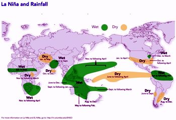
La cartina a fianco mostra quali potrebbero essere le aree più a rischio di alluvioni e di siccità. Tra le aree a rischio alluvione, oltre l’Australia e l’Indonesia, vi sono (da ora fino al mese di aprile) anche la parte meridionale dell’Africa e la parte nord orientale del sud America. Tra le aree a rischio siccità, invece, ci sono tutte le isole del Pacifico comprese nella fascia equatoriale, una zona subequatoriale dell’Africa orientale che va dalla Somalia alla Tanzania, e una fascia che comprende il sud degli Usa ed il nord del Messico.
Di seguito pubblichiamo l’avviso dell’Iri, reperibile anche sul sito. (V. F.)
——–
La Niña Related Impacts Likely to Continue
(The full story, with graphics and video interviews is here: http://bit.ly/lanina2011)
As of mid-January, moderate-to-strong La Niña conditions continue to exist in the tropical Pacific. Scientists at the International Research Institute for Climate and Society expect these to linger, potentially causing additional shifts in rainfall patterns across many parts of the world in months to come. These shifts, combined with socioeconomic conditions and other factors, can make some parts of the world more vulnerable to impacts. However, La Niña conditions do allow the IRI and other institutions to produce more accurate seasonal forecasts and help better predict extreme drought or rainfall in some parts of the world. This enhanced predictability could help societies improve preparedness, issue early warnings and reduce any potentially negative impacts from La Niña.
“Based on current observations and on predictions from models, we see at least a 90% chance that La Niña conditions will continue through March 2011,” says IRI’s chief forecaster, Tony Barnston.
The term La Niña refers to a period of cooler-than-average sea-surface temperatures in the eastern and central equatorial Pacific Ocean that occurs as part of natural climate variability. This situation is roughly the opposite of what happens during El Niño events, when waters in this region are warmer-than-normal. Both are part of a larger climate cycle known as the El Niño-Southern Oscillation, or ENSO. Because the Pacific is the largest ocean on the planet, any significant changes in average conditions there, such as those that occur during La Niña or El Niño, can have consequences for temperature, rainfall and vegetation in faraway places.
Climate scientists have found La Niña’s signature in the widespread flooding that occurred in Pakistan last year, as well as flooding in West Africa, South Africa, and most recently in Queensland, Australia, where an area estimated to be the size of France and Germany combined was left underwater. Places such as Indonesia and northern South America have also been receiving above-normal rainfall. But La Niña probably isn’t to blame for the recent flooding in southeastern Brazil, says Barnston. The more likely culprit there was a pocket of above-average sea-surface temperatures in the southwest Atlantic that promoted low atmospheric pressure and an increased tendency for heavy rainfall.
La Niña can be associated with droughts as well. It’s keeping east Africa drier-than-usual, sparking food-security concerns in areas lacking irrigation, including parts of Somalia, Kenya, Ethiopia and Tanzania. Areas in southeastern South America, central southwest Asia, and the southern U.S. may also see lower-than-normal rainfall for the first quarter of 2011.
Since 1950, the world experienced six major La Niña events, which were linked to widespread flooding in some areas. For example, in Bangladesh, La Niña was implicated in four out of six devastating flood events documented since 1954 (read more here). In 2000, floods associated with La Niña affected 400,000 people in southern Africa, caused at least 96 deaths and left 32,000 homeless. Of course, such events can also occur during non-La Niña years. What La Niña does is increase the likelihood that certain areas will get above-normal or below-normal rainfall (see map on this page for more details).
Once developed, La Niña conditions typically persist for 9-12 months, peaking sometime during November, December, or January. But 2010 was an interesting and lively year for climate scientists. For the first four months of this year, El Niño conditions prevailed in the tropical Pacific, but that quickly changed, and by June, a La Niña pattern had emerged.
“Last year’s transition from El Niño to La Niña was about the most sudden we’ve ever had,” Barnston says. “When we had rapid flips like this in the past, we sometimes ended up having a two-year La Niña, such as right after the El Niño episodes of 1972/73 and 1997/98.” Barnston cautions that the likelihood of this happening with the current La Niña is unknown. “Even if we do have a second year of La Niña developing in northern summer 2011, we expect at least a brief return to neutral conditions from May to July of 2011”.


